Accurate prep for hikes: New Task (Hard)
Harry enjoys the idea of hiking and has gone on a few hikes with his friends. But every time he goes on a hike with them, he forgets to bring something! Sometimes he’s a little short on food, sometimes he doesn’t realize the trail is muddy so he forgets his waterproof boots, and he sometimes even forgets to bring a backpack. He wants a way to know what he needs for a specific route and he also wants to be able to check each item off as he is preparing so he knows that he has everything he needs for a fun hike! Right now he’s trying something new by looking online to find out what to bring to accurately prepare for a hike. The difficulty with this is that the information he finds is often quite general. This means that he won’t be able to bring exactly what he needs. Often times he will find himself bringing way more or way less things than what he needs. This task is quite difficult because it puts Harry in a spot where he could end up getting hurt if he does not prepare for his hike adequately.
Accurate prep for hikes - Easy/Existing
Harry enjoys the idea of hiking and has gone on a few hikes with his friends. But every time he goes on a hike with them, he forgets to bring something! Sometimes he’s a little short on food, sometimes he doesn’t realize the trail is muddy so he forgets his waterproof boots, and he sometimes even forgets to bring a backpack. He wants a way to know what he needs for a specific route and he also wants to be able to check each item off as he is preparing so he knows that he has everything he needs for a fun hike! Right now he’s trying something new by looking online to find out what to bring to accurately prepare for a hike. The difficulty with this is that the information he finds is often quite general. This means that he won’t be able to bring exactly what he needs. Often times he will find himself bringing way more or way less things than what he needs. This task is quite difficult because it puts Harry in a spot where he could end up getting hurt if he does not prepare for his hike adequately.
Finding hikes that are good for their skill level - Hard/Existing
Eduardo wants to hike on his own, but he has no idea what trails would be good for him to start out on. None of his friends hike so he can’t get information from them. The resources online don’t take into account his fitness level or his experience with hiking. This results in Eduardo not being able to find hikes tailored to his skill level easily and this ruins his experience. This is because he will either have to go on the hike not knowing how hard it will be to finish due to his ignorance of the difficulty level. What he needs is a reliable way to find hikes appropriate for him. Currently he goes out and takes notes on the hikes that he currently knows how to complete. This is moderately difficult because he has to store this data somewhere. Not only does he have to keep track of whether or not he can complete the hike, but he has to also keep track of the experience he had while going on a specific hike. This includes things like how difficult it was at certain parts, what he saw, things to be aware of the next time he goes and where to find certain resources such as food, water and a resting spot. Recording all of this information with precision is sometimes hard for him because he has to stop his hike to write down the information he has and this distracts him from the experience he wants.
Never get lost during a hike - Hard/New
Ryan is an intermediate hiker who loves walking trails on his own. However, the thought of getting lost on a long hike terrifies him so he rarely goes on hikes longer than a few miles even though he enjoys the idea of longer hikes. Right now he uses the trail markers to make sure he’s on the right path, but this is moderately difficult as he recognizes that there is no easy way to tell at what point he veered off the trail or how to get back on the trail if he were to get lost. He wants a more reliable way of making sure he is headed in the right direction during a hike so he can worry less while on the trails.
Identify wildlife around them - Hard/Existing
Sally is a curious, outdoorsy person who likes to be around nature. While she loves just being surrounded by trees, flowers, and animals, she often finds flora and fauna that she isn’t familiar with and her curiosity leads to her trying to identify them. For her, this means either having a field guide with her anytime she goes out on walks or googling the features of the subject and risking an incorrect result for flower or tree she is looking at. This task is quite tedious and difficult because he has to get the details down perfectly such as the structure of the stem, the color of the petals and sometimes even the type of root. She wishes there was a way for her to easily verify what the things around her are.
Keep track of progress during hike - Medium/New
Raquel is a fearless explorer. She could be a beginner or expert, but nonetheless, loves to take trips out to the wilderness and explore new trails. Even though she is brave, there are times where she would like to know how far she is into a hike. Whether she is short on time, pacing herself, or would just like to know where she is relative on a map, she still wonders where her exact location is on the trail. At the moment, the best Raquel can do is estimate where she is on a new hike; being exposed to unfamiliar surroundings, she semi-blindly treks to the end. But knowing where she is on the trail could give her the confidence to conquer any journey. In the case of emergency, Raquel also needs to know where the closest place to get help is. Should she stay put, go back, or keep hiking forward? She couldn’t possibly decide unless she knew her location. The estimation of her position is not very difficult for Raquel, basing her guess on the total hike distance and how far she feels she has hiked, but it is very difficult for her to verify the validity of her guess.
Locate natural resources for survival - Medium/Existing
Nick is an up-and-coming backpacker. Despite being an avid hiker for many years, he has just got into the backpacking itself. He loves it. Even having just gone out with his friends a few times to the local wooded mountains, Nick craves a more intense experience, perhaps a solo backpacking trip for an extended period of time. He is used to finding clean water sources with trail maps and the help of others and has got into foraging with the help of his friends and a field guide. So, Nick has also had his first experiences with survival in the wilderness. However, before Nick can rise to new challenges, he needs help. On the trails before, he was unsure whether the water source he was led to was really clean and whether the berries he found were the edible ones in the field guide. This task is difficult to get over without a lot of experience. He desires an easier and faster way to locate natural clean water and food sources.
Smart Watch Design
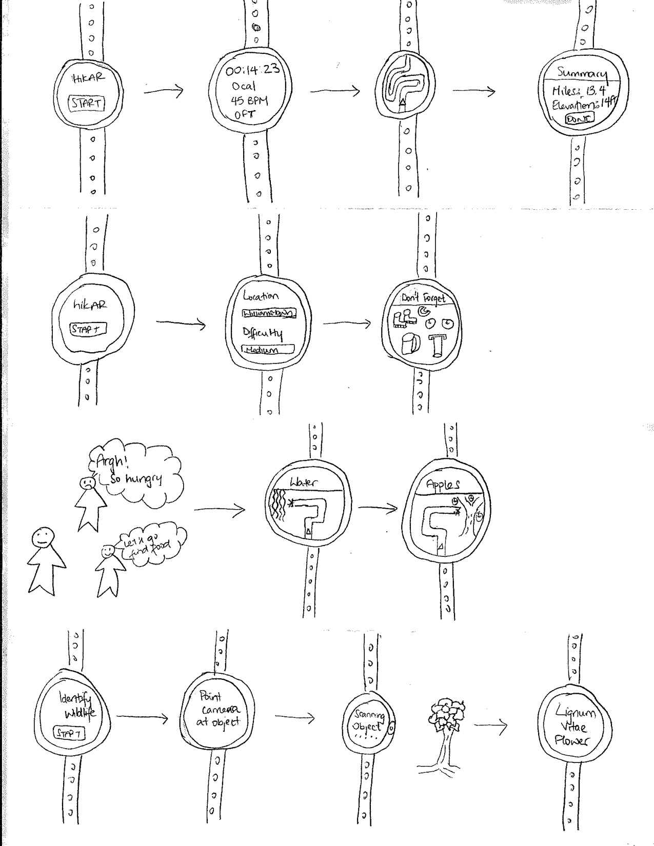
The hikAR Smart Watch is designed to help users with their hike while avoiding the intrusive aspects of other potential designs. Before the user goes on their hike, the watch will allow them to select the difficulty of the hike that they wish to go on and will then generate a list of trails near them that are of that difficulty. Once they select a trail, the app will generate a list of things to bring which will be compiled based on conditions such as weather and recommendations from other hikers. While on the trail, the watch will allow the user to access key information such as their calorie count, their heart rate, and their overall progress for the hike. If the user needs more water or food, the watch will reroute them toward nearby natural resources. Using a camera on the watch, the user will also be able to identify wildlife around them and thus learn about nature while on their hike.
Task One: Keep track of progress during hike
The hikAR Smart Watch will allow our customers to keep track of their hike as they are on their journey. It will show them all of the critical information that they will need while going on the hike. This includes information such as the current timer, their calorie count, their heart rate, altitude etc. Another screen will show them the current hiking route that they are on. This highlights the routes clearly and leads our customers to their destination. When the hike is over, it will automatically give them a summary of their hike so that they can view it at another time.
Task Two: Accurate Prep for Hike & Difficulty Level
The hikAR Smart Watch will allow our customers to easily prepare for the hike ahead. It will allow them to enter the location/ automatically select it based on GPS features. It will then allow the hiker to pick the difficulty that they would like to go on. After this, the app will generate a list of things for the hiker to bring. This list comes from several conditions such as weather, the hiker’s current health and recommendations based on other hikers.
Task Three: Locate Natural Resources for Survival
The hikAR Smart Watch will allow our customers to find the necessary resources needed when they begin to feel hungry while out on the hike. This includes resources such as water and food. It will automatically reroute our hikers to closest water supply or food supply depending on their choice. This is done in a way that the hiker does not have to go off route too much and can easily return on their normal route once they have obtained resources to allow them to finish the hike.
Task Four: Identifying Wildlife
The hikAR Smart Watch will allow our customers to locate and identify certain wildlife that is out and about. The camera will be able to point at specific wildlife and be able to identify it. It will give details about it so that the customers interested can find out more about it. An important concept from this is that our customers will be able to locate wildlife that is edible or not. They will simply point the camera at the object and our app will tell them if it can be eaten or if they should stay away.
Mobile App + Camera Design
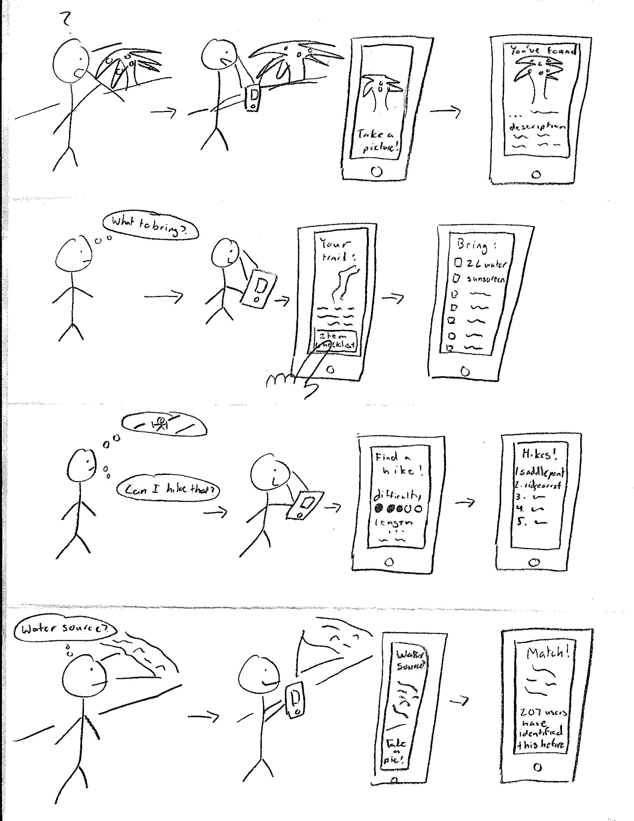
This design is a mobile app which uses the phone / mobile device’s camera to solve most of the user problems and tasks. When deciding on a trail, users can use the app to find a trail that matches their skill level and other interests. Prior to the hike, the app will also provide the user a checklist of recommended items and supplies. While on the trail, the user can use the app + their camera to identify wildlife and other natural resources (like water sources).
Task One: Accurate Prep for Hikes
Before a user embarks on a hike they have searched for / planned through hikAR, the app will alert them and send a notification to check off a list of items and supplies they should bring on the hike. These checklists will be created by designated trail experts and hikAR community members. Additionally, if a user wishes to just use the app as a pre-hike tool, they can search for item checklists by trails.
Task Two: Finding Hikes That Are Good for Their Skill Level
The hikAR mobile app will provide an easy interface for users to pick and choose hiking trails. One filtering feature will be hike difficulty. To determine a user’s skill level, the hike will monitor and keep track of the difficulty of hikes that the user has previously finished. Or, the user can simply fill out a quick questionnaire regarding their experience and athletic ability in order for the app to give an estimate of the skill level as well. The user has the option to input a hike difficulty represented by 5 filled/empty circles. Once done, the results will be filtered with those hikes with that difficulty at the top of the list.
Task Three: Identify Wildlife Around Them
The mobile device camera will be the focal point through which wildlife identification will be achieved. If the user sees something in the wilderness they will have two means of identification through the mobile app. One of course will be the camera, in which case if the user can take a good picture of the animal, plant, etc. the app will return an info page about that piece of wildlife. There, the user can verify if the identification was correct and learn more about it as well. The validity checking will be essential to the correct identification of wildlife for others in the future (image data). The user can also fill out a questionnaire, answering questions about the wildlife much like a field guide except here electronically, to figure out what they are looking at.
Task Four: Locate Natural Resources for Survival
HikAr’s mobile app will help users locate natural resources on their hikes. The wildlife identification feature will allow users to correctly identify edible plants and fruit on their trails. Also, the app will help users find clean water sources. If desired, a user can use the app to guide/route them towards clean water sources. However, if a user is still not sure if the water source they see is the designated source for the trail, they can simply take an image of the water source. If the image matches the images from previous users who verified the source, the app will report it as a match and that it is likely that the hiker is looking at the correct water source.
AR Glasses

This design is a pair of AR glasses which utilizes the AR aspect to allow users an avenue to learn about the world around them and navigate safely while on hikes. When deciding on a hike, the user will be able to select from a number of routes that are sorted by difficulty level. The glasses will then provide a checklist of items needed and the recommended amounts of each item depending on the length of the hike and the conditions of the trail. While on the hike, hikAR’s navigation system will make sure the user doesn’t get lost while also pointing them toward key resources when they need to resupply. The device will also allow for quick, accurate information on local wildlife whenever the user is curious and wants to know more about a tree they saw, for example.
Task One: Accurate Prep for Hikes
Before a hike, the glasses will present the user with a list of potential routes tuned to the user’s skill level and preferences. Once the user selects a route, a list of items that the user should make sure to take with them will be shown to them and they can check off items from the list as they acquire them. The list of items will change according to how long the hike is, the weather conditions, and other factors.
Task Two: Never Get Lost During a Hike
While on the hike, the user will see a blue line along the path that they should be traveling. If the user goes off in a different direction, hikAR will point them back in the correct direction. This will hopefully not be disruptive as the pathfinder will only appear when the user requests it rather than being constantly present. In case the user needs to return home, hikAR will also allow for that as an option and will safely guide users back to their starting point.
Task Three: Identifying Wildlife
When the user looks at an unfamiliar animal or plant, they can switch hikAR’s mode into Identification Mode. In this mode, the glasses will provide information in a text box if the user specifically states that they want to know more about the object they are looking at. This will help people who are curious about the world around them learn more while on their hike.
Task Four: Locate Natural Resources for Survival
Although the glasses will give a checklist before the hike that, in part, suggests a certain amount of water to bring on the hike depending on the hike’s length, there might come a time when hikers need or would just like to either forage for food or find fresh-water to replenish their resources. When this happens, the user can switch hikAR to Resource Mode and select the resource they need. In this mode, the previously mentioned blue line guiding the user along the trail will now guide the user to the nearest stream if they are in need of water. Once the user has finished gathering resources, hikAR will then guide the user back onto the route.